
"When efficiency and precision matters"
www.africansurveyors.com
"The sea, once it casts its spell, holds one in its net of wonder forever." — Jacques Cousteau
Coastal development and maritime activity are on the rise across the African continent. Ports are expanding. Offshore infrastructure is evolving. And with it comes the growing demand for precise, data-rich Hydrographic Surveys. At African Consulting Surveyors (ACS), we understand that accurate mapping below the waterline is as critical as what's above it — especially when human safety, environmental sustainability, and economic viability are all at stake.
Hydrographic Surveys involve the measurement and mapping of the physical features of bodies of water and their surrounding shorelines. These surveys provide critical information about water depth, seabed contours, sediment types, currents, and submerged hazards. They play a foundational role in everything from port construction to pipeline placement, and even in preserving marine ecosystems.
Whether we’re charting deep ocean floors or shallow inland waterways, the goal remains constant: deliver reliable data that informs decision-making and enhances project outcomes.
For centuries, sailors relied on ropes and lead weights — the “lead line” — to measure water depths. While rudimentary, this technique laid the groundwork for modern hydrography. Today, we employ sophisticated technologies like multibeam sonar, LiDAR, and differential GPS to gather tens of thousands of soundings in minutes.
This transformation didn’t happen overnight. It evolved from wire-drag methods to acoustic and satellite-based systems. Each leap brought greater speed, precision, and safety — hallmarks of ACS’s hydrographic surveying services today.
Hydrographic Surveys are often the first step in coastal and marine development projects. They ensure vessels can navigate safely, avoiding uncharted shoals or debris. In engineering applications, these surveys guide design decisions by delivering high-resolution data on underwater terrain and soil conditions.
We’ve worked on everything from harbour expansions and beach nourishment to underwater cable routing and offshore drilling. The common thread? Every successful outcome began with a site survey that included underwater mapping.
These surveys are also vital in responding to natural disasters. After hurricanes or tsunamis, our teams are deployed to assess how sea floors have shifted and to help authorities reopen ports and shipping lanes safely.
At ACS, we don’t view Hydrographic Surveys in isolation. We integrate them with complementary services to build a complete spatial understanding of a site.
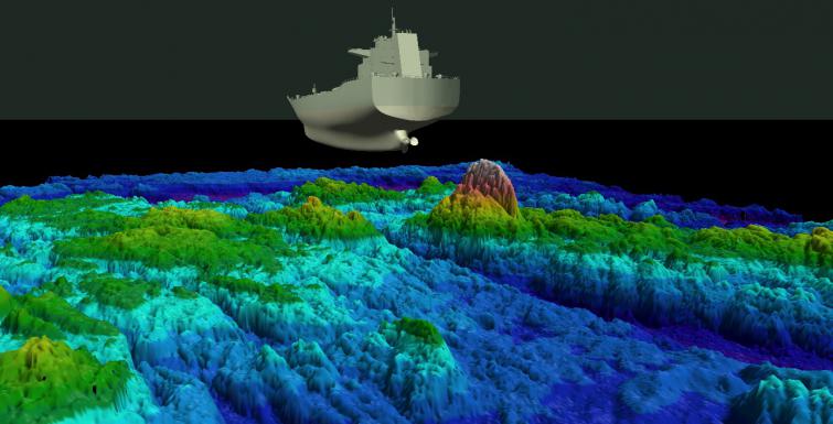
For example, 3D Modelling brings underwater data to life. Using sonar data and terrain modelling software, we construct detailed visualisations of seabeds and river channels. These models help engineers and planners assess feasibility, visualise risk, and simulate environmental scenarios.
Large Format Aerial Photography gives us a macro view of the coastline and surrounding terrain. When combined with hydrographic data, it allows stakeholders to visualise the interaction between land and water more comprehensively.
When precision beneath the ground is also required — say, to detect buried pipelines or cavities — we employ GPR Surveys (Ground Penetrating Radar) to complement the hydrographic findings. This layered insight is especially valuable for projects that involve both underwater and terrestrial components.
Additionally, our Drone Surveys enhance our capabilities in hard-to-reach or environmentally sensitive coastal zones. By flying high-resolution cameras and LiDAR sensors over target areas, we gather rapid data with minimal disruption to the surrounding environment.
Finally, all of this data feeds into an overarching Site Survey, a comprehensive assessment that becomes the backbone of planning, permitting, and construction phases.
Hydrographic Surveys are not just maps of the ocean floor. They are decision-making tools used in:
Whether we’re supporting a marine construction project or helping a municipality plan sustainable shoreline development, hydrographic data reduces uncertainty — and with it, risk.
African Consulting Surveyors stands at the intersection of tradition and innovation. Our surveyors use cutting-edge technology and proven methodologies to deliver trusted results. But beyond the data, we are committed to responsible surveying practices that respect both human and environmental needs.
As marine infrastructure becomes more complex and the demand for accuracy grows, Hydrographic Surveys are more relevant than ever. They’re not just about the depth of water — they’re about depth of understanding.
With Africa’s coastal cities expanding rapidly and maritime industries booming, high-quality Hydrographic Surveys are essential. At ACS, we’re proud to be enabling smarter, safer, and more sustainable development across the continent’s waterways.
From seabed to shoreline, our work supports the lifeblood of global trade, environmental conservation, and national infrastructure. Let’s continue to map the depths — and in doing so, raise the standard for what’s possible on and below the waterline.