
"When efficiency and precision matters"
www.africansurveyors.com
That wonder becomes manageable when technology meets precision—and that’s exactly where the hydrographic survey vessel takes centre stage. While the world above the waves gets the spotlight, beneath the surface lies a world of critical data that informs everything from safe navigation to national infrastructure. And it all begins with accurate, actionable mapping.
At African Consulting Surveyors, we’ve seen first-hand how the value of high-resolution bathymetric data can shape projects, protect vessels, and enhance planning in ways few realise.
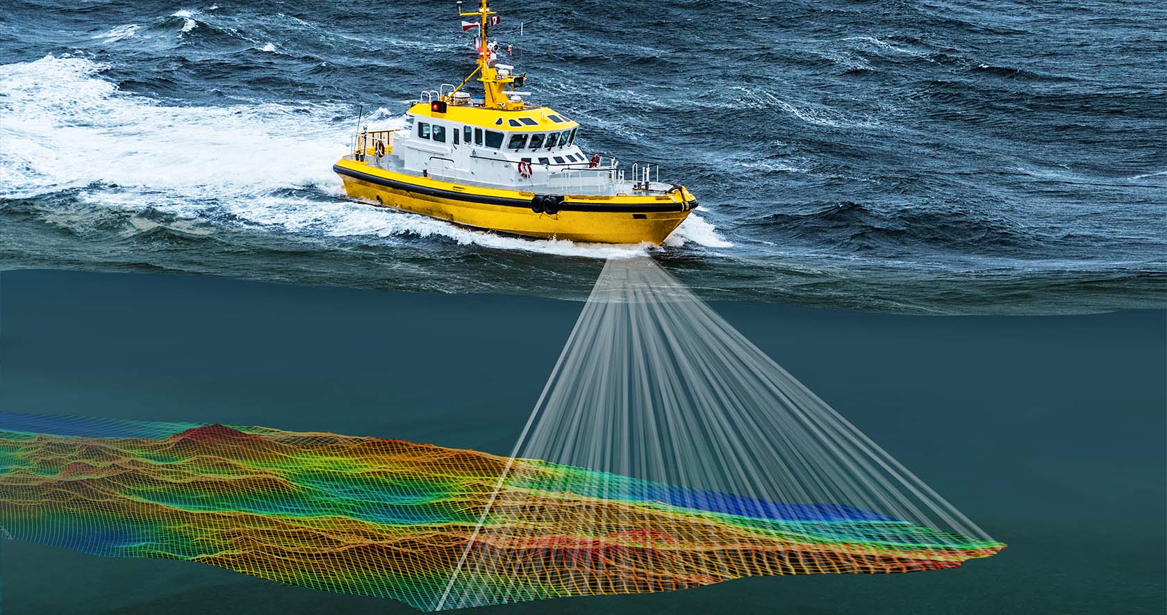
A hydrographic survey vessel is more than just a boat. It’s a floating command centre, outfitted with sonar, GPS, echo sounders, and other advanced tools to scan and document the seabed. Its primary role is to determine underwater topography—mapping the sea floor to support marine navigation, coastal engineering, and resource planning.
These vessels also deploy smaller “daughter vessels,” especially in shallow or hard-to-navigate areas, ensuring precision even in complex environments. Whether you're charting a new shipping route or installing marine infrastructure, this vessel is your foundation for reliable geospatial intelligence.
Using multi-beam sonar and real-time kinematic positioning systems, these vessels measure water depths and identify underwater hazards like wrecks or submerged pipelines. That’s what makes them indispensable for updating nautical charts and verifying the position of buoys and other maritime markers.
A common misconception is equating hydrographic survey vessels with marine surveying. While both involve inspection, their roles are worlds apart.
Marine surveyors focus on assessing a vessel’s condition and seaworthiness—especially relevant when you need a survey for boat insurance. Conversely, hydrographic surveyors are concerned with collecting spatial data about marine environments. One inspects the ship. The other maps the world beneath it.
What can a hydrographic survey vessel actually do? The answer spans industries. These vessels support the construction of harbours, bridges, wind farms, and undersea cables. They aid in environmental monitoring, dredging operations, and marine habitat conservation.
Their data is also frequently integrated with lidar aerial mapping to create full 3D models of coastal areas—above and below water. That’s where tools that monitor for 3D modelling come into play, helping engineers visualise and plan projects with remarkable clarity.
At African Consulting Surveyors, we often combine marine surveys with cadastral survey data, particularly when coastal development or land reclamation intersects with legal land boundaries. This integrated approach ensures accuracy in both maritime and land-based zones—a critical advantage for clients dealing with regulatory compliance or development permits.
Hydrographic data plays a key role in complex industrial ecosystems. For example, a process plant operator overseeing coastal facilities must understand underwater terrain to plan intakes, outfalls, or transport channels. Similarly, hydrography informs risk assessments and logistics around processing plants. Examples include offshore oil rigs or desalination plants—where location accuracy can directly affect safety and performance.
As digital twins and smart infrastructure advance, the role of hydrography is only expanding. Data collected by a hydrographic survey vessel is now regularly integrated into GIS platforms, simulation software, and marine construction planning tools. When paired with technologies like lidar aerial mapping, teams can achieve seamless above-and-below-ground modelling—supporting everything from climate change monitoring to disaster response planning.
With automation, drone-assisted scanning, and real-time data streams, the field is becoming faster, safer, and more precise than ever.
Whether you’re a developer, engineer, environmental planner, or a national infrastructure stakeholder, understanding the seabed isn’t optional—it’s essential. And no tool delivers that understanding better than the hydrographic survey vessel. It’s the quiet workhorse beneath nearly every successful marine operation, delivering insight, safety, and confidence where it matters most.
At African Consulting Surveyors, we’re proud to bridge land and sea with data that builds the future—above and below the waterline.