
"When efficiency and precision matters"
www.africansurveyors.com
“The bitterness of poor data lingers long after the sweetness of fast delivery is forgotten.”
That quote may resonate deeply if you’ve ever made a costly project decision based on incomplete or unclear plans. In the realm of surveying, engineering, and construction, clarity and precision are non-negotiable—and that’s where the difference between 2D and 3D modelling becomes not just a technical matter, but a strategic one.
At African Consulting Surveyors, we’ve spent decades working at the intersection of data and design. Whether your project involves navigating tight urban corridors or mapping expansive landscapes with Ground Penetrating Radar, knowing when to use 2D versus 3D can save you time, resources, and costly rework.
Let’s break it down.
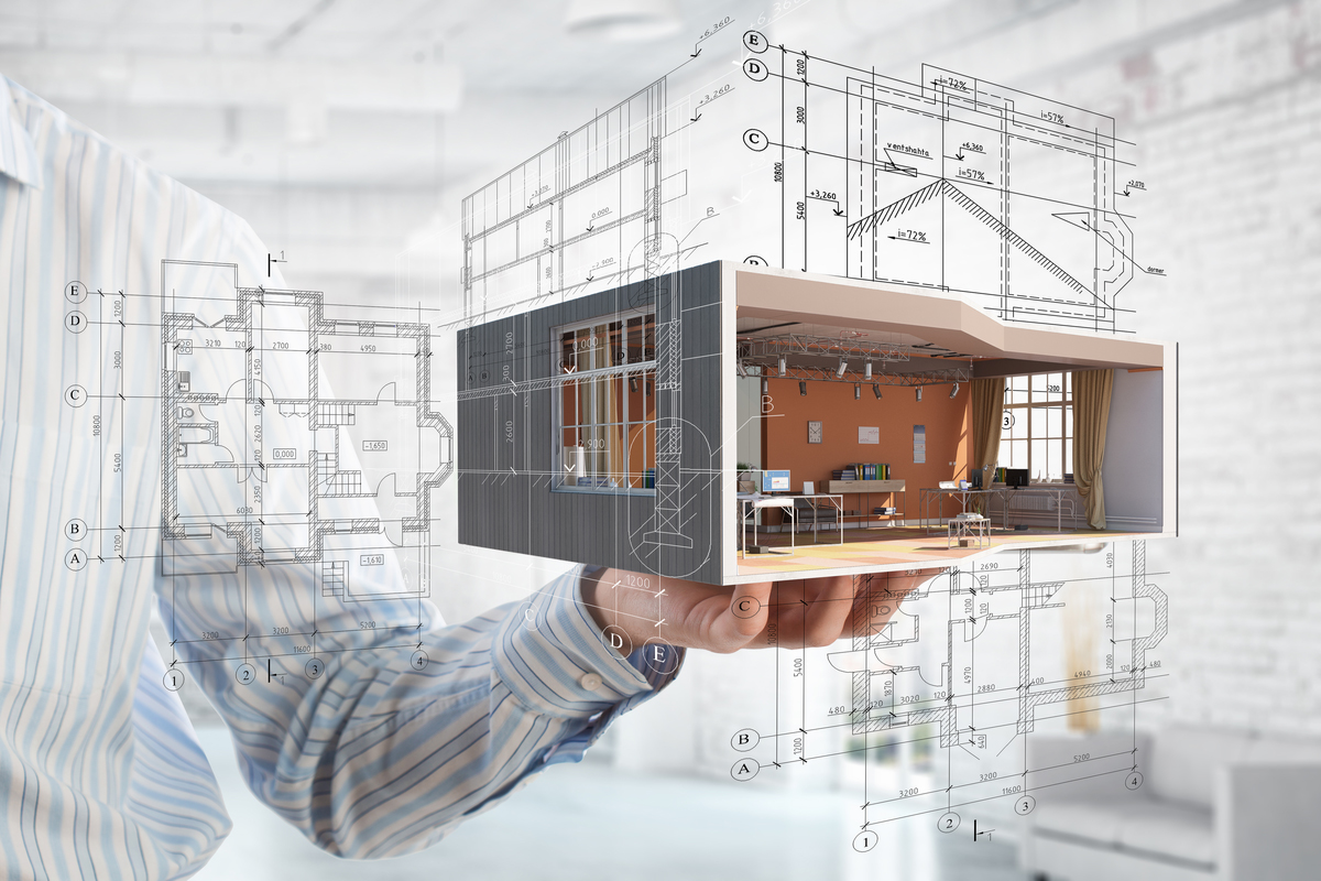
2D modelling is the traditional blueprint of the built environment. It captures spatial relationships using two axes: length and width. For decades, engineers, architects, and surveyors have used 2D plans to communicate layout, dimensions, and design intent. These drawings are simple to produce and ideal for conveying basic information at a glance.
However, 2D has its limits. It doesn’t account for depth, and that can make visualising complex elevations or underground utilities tricky. A 2D model of a coal plant process, for example, might clearly show piping routes and equipment layout, but without depth, it’s far harder to anticipate spatial conflicts or volume requirements.
That’s where 3D steps in.
3D modelling introduces a third axis: height or depth. It transforms flat drawings into fully formed digital environments that can be rotated, zoomed, and examined from every angle. In short, it’s a more lifelike representation of the real world.
From hydrographic survey equipment applications to virtual terrain models generated by drones, 3D modelling allows teams to integrate huge amounts of data—topography, structures, utilities, and even vegetation—into a unified visual experience. This is especially useful when paired with reality capture tools, such as those used to create a LiDAR map, which can feed precise elevation data into your model for an unprecedented level of spatial accuracy.
Let’s address the heart of this article: the difference between 2D and 3D modelling isn’t just about adding another dimension—it’s about adding value.
In 2D, you can measure a line. In 3D, you can simulate an entire phase of construction. 2D plans are static. 3D models are interactive, visual, and layered with metadata that helps planners, contractors, and clients better understand what’s being built and why.
In many cases, 2D is still valuable—especially for simple layouts, quick cross-sections, or teams using older field tools. But in complex or high-stakes environments, like in types of engineering survey that involve terrain deformation or infrastructure clashes, 3D models offer insights you simply can’t extract from flat plans.
For boundary mapping or bulk earthworks, 2D site plans are often enough to estimate volumes or assess surface area. But as soon as terrain complexity or existing infrastructure is involved, 3D becomes vital.
Using LiDAR or drone photogrammetry, we can build high-resolution 3D models that integrate seamlessly into civil engineering workflows. This data can help prevent design clashes before construction begins.
When subsurface accuracy is essential—like when using Ground Penetrating Radar to detect buried utilities or voids—3D visualisation makes it much easier to identify where risks exist and how deep they are. These models can also be layered with other datasets, improving both communication and decision-making.
It’s worth saying: 2D isn’t obsolete. For quick cut-and-fill calculations, high-level progress maps, and compatibility with legacy systems, 2D plans are still incredibly useful. Many clients prefer them for basic overviews, and they’re often easier to reference on handheld devices in the field.
Plus, when delivering reports on infrastructure like roads or site fencing layouts, 2D plans remain the preferred documentation format for permitting and compliance.
However, as projects become more complex and interdisciplinary, 3D shines. Consider the construction of a multilevel processing facility for a coal plant process—it involves dense piping networks, heavy mechanical installations, and multiple contractor teams.
Here, a 3D model not only shows spatial relationships but can simulate staging, identify structural clashes, and even link to live databases for project tracking. In some cases, we integrate these models with machine control systems for autonomous grading—saving days, even weeks, on sitework.
In many of our projects, we combine both models. A LiDAR map provides a detailed surface layer, which we convert into a 3D base model. From there, we extract 2D plan views for simplified reporting and communication. This hybrid approach ensures that all stakeholders—from architects to machine operators—can access the data they need, in the format they understand best.
It’s also an essential part of our work in hydrographic surveying, where 3D seabed models enhance navigation safety, while 2D cross-sections support permitting and reporting.
To sum it up: the difference between 2D and 3D modelling is more than just dimensionality. It’s about choosing the right tool for the task. Use 2D for speed and simplicity. Use 3D for clarity, accuracy, and insight.
At African Consulting Surveyors, we tailor every project’s modelling strategy based on complexity, budget, and desired outcomes. Whether you need 2D plans for planning permissions or immersive 3D models for machine-guided construction—we’re here to guide you through it.
Have questions? Let’s talk. Whether you’re designing a dam, mapping a mine, or laying out a power station, we’ll help you build it better from the ground up.