
"When efficiency and precision matters"
www.africansurveyors.com
"The best way to predict the future is to create it." When it comes to mapping our world, LiDAR Mapping is creating the future of geospatial analysis. This advanced technology is reshaping industries by offering high-precision, high-speed, and highly detailed data collection that was once impossible with traditional surveying methods. From urban planning and infrastructure to environmental conservation and industrial applications, LiDAR is setting new standards for accuracy and efficiency.
At African Consulting Surveyors, we understand the critical role of geospatial data in shaping smarter decisions. With LiDAR Mapping, professionals can now visualize landscapes in 3D, penetrate dense vegetation to uncover hidden terrain, and integrate vast datasets seamlessly into Geographic Information Systems (GIS). Whether in engineering surveys, process plants, or large-scale infrastructure projects, LiDAR is transforming the way we capture and analyze the world around us.
LiDAR (Light Detection and Ranging) is a remote sensing method that uses laser pulses to measure distances between a sensor and the Earth's surface. Mounted on aircraft, drones, satellites, or ground-based platforms, LiDAR sensors send out rapid laser pulses that reflect off objects below. By calculating the time it takes for each pulse to return, LiDAR creates incredibly precise 3D elevation models of terrain, buildings, and vegetation.
A LiDAR Mapping system consists of three main components: a laser scanner, a GPS receiver, and an Inertial Measurement Unit (IMU). The laser scanner emits pulses that reflect off surfaces, the GPS determines the exact position of the sensor, and the IMU tracks motion and orientation. Together, these components ensure centimeter-level accuracy, making LiDAR one of the most powerful tools in geospatial technology today.
Unlike traditional surveying techniques, which require extensive ground measurements, LiDAR Mapping collects vast amounts of data in a fraction of the time. Its precision is unmatched, capturing elevation differences, surface structures, and even subtle variations in terrain that are often overlooked by satellite imagery or photogrammetry.
One of LiDAR’s most impressive capabilities is its ability to penetrate dense vegetation. While aerial photography can be blocked by tree canopies, LiDAR pulses can pass through small gaps in the foliage, reaching the ground below. This makes it invaluable for forestry management, archaeology, and environmental conservation.
LiDAR is an active sensor, meaning it does not rely on sunlight to capture images. Unlike traditional aerial imaging methods that depend on daylight conditions, LiDAR Mapping can be conducted both day and night, providing flexibility for surveyors and project managers working on tight deadlines.
City planners and engineers use LiDAR Mapping to model urban environments with exceptional detail. From designing transportation networks to assessing flood risks in developing regions, LiDAR-generated elevation models provide crucial insights that guide smarter city planning and development.
Ecologists and conservationists rely on LiDAR Mapping to assess forest health, measure tree density, and monitor environmental changes over time. By analyzing LiDAR data, specialists can identify deforestation trends, track wildlife habitats, and develop sustainable land management strategies.
Governments and emergency response teams use LiDAR to map floodplains, identify high-risk areas, and create evacuation plans. The ability to generate Digital Terrain Models (DTM) and Digital Elevation Models (DEM) helps predict water flow and potential flood zones with unprecedented accuracy.
LiDAR technology has revolutionized archaeology by uncovering ancient settlements hidden beneath dense forests. Researchers have used LiDAR Mapping to reveal lost cities, buried road networks, and prehistoric landscapes that were previously impossible to detect.
When combined with GIS software, LiDAR data becomes even more powerful. GIS allows users to layer LiDAR-generated 3D models with existing maps, satellite imagery, and geospatial datasets. This fusion of information enhances site planning, infrastructure monitoring, and land-use management across industries.
LiDAR is not the only tool in geospatial analysis. Many projects benefit from integrating LiDAR Mapping with photogrammetry and satellite imagery. While LiDAR excels in capturing terrain details, photogrammetry provides rich color information, and satellite imagery offers a broad regional perspective. When used together, these technologies create a comprehensive geospatial dataset that supports informed decision-making.
Despite its advantages, LiDAR Mapping is resource-intensive. The equipment, software, and skilled professionals required for data collection and processing can make LiDAR a costly solution. However, as technology advances and costs decline, LiDAR is becoming more accessible across industries.
LiDAR generates enormous datasets that require powerful computing resources for processing. Managing and storing this data efficiently is a challenge, particularly for large-scale mapping projects. Cloud-based GIS platforms are helping alleviate this issue by enabling real-time collaboration and scalable storage solutions.
Landscapes change rapidly due to urban development, deforestation, and natural disasters. While LiDAR Mapping provides a highly accurate snapshot, it requires regular updates to maintain relevancy. Companies that rely on LiDAR must plan for periodic resurveying to ensure their data remains up to date.
Artificial intelligence is streamlining LiDAR workflows by automating feature extraction, pattern recognition, and anomaly detection. AI-powered LiDAR analysis is improving efficiency in process plants, smart cities, and environmental monitoring.
The future of LiDAR Mapping lies in cloud-based platforms that allow for seamless data sharing, collaborative analysis, and real-time updates. This shift is making LiDAR more accessible to businesses, governments, and research institutions worldwide.
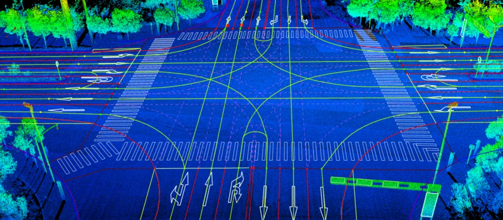
Autonomous vehicles rely on LiDAR Mapping for navigation, obstacle detection, and route optimization. As self-driving technology evolves, LiDAR will continue to play a central role in ensuring safety and efficiency in smart cities.
From engineering surveys to environmental conservation, LiDAR Mapping is transforming the way we understand and interact with our world. With the support of Geomatics Companies in South Africa, industries can leverage LiDAR technology to improve planning, optimize operations, and drive sustainable growth.
At African Consulting Surveyors, we are committed to providing industry-leading LiDAR solutions that enable professionals to make data-driven decisions with confidence. The future of mapping is here, and LiDAR is at the forefront of this revolution.